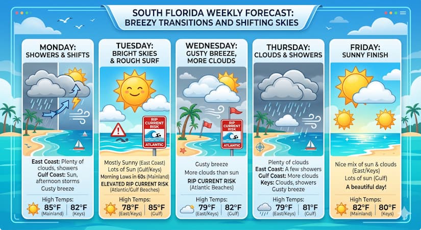
Monday showers transition to Tuesday sunshine while gusty breezes and rip current risks impact the region all week.
Monday features plenty of clouds and periods of showers in the East Coast. The Gulf Coast will see good sun, some clouds, and periods of showers and storms on a gusty breeze in the afternoon and evening as a front moves in. Look for sun and some clouds on a gusty breeze in the Keys. Monday’s highs will be in the mid-80s on the mainland and in the low-80s in the Keys.
Tuesday will bring morning lows in the 60s on the mainland and breezy conditions around South Florida. The East Coast will be mostly sunny, while the Gulf Coast and the Keys will see lots of sun. Expect an elevated risk of dangerous rip currents at the Atlantic and Gulf beaches. Tuesday’s highs will be in the upper 70s on the East Coast and the Keys, and mostly in the mid-80s along the Gulf Coast.
Wednesday will feature a gusty breeze and more clouds than sun around South Florida. Expect an elevated risk of dangerous rip currents at the Atlantic beaches. Wednesday’s highs will be in the upper 70s in the East Coast and the Keys and the low 80s along the Gulf Coast.
Thursday will see plenty of clouds on a gusty breeze and a few showers in the East Coast. The Gulf Coast will see more clouds than sun. Look for clouds and some showers in the Keys. Thursday’s highs will be in the upper 70s in the East Coast and the Keys and in the low 80s along the Gulf Coast.
Friday’s forecast calls for a nice mix of sun and clouds in the East Coast and the Keys, and lots of sun along the Gulf Coast. Highs on Friday will be in the low 80s on the mainland and near 80 degrees in the Keys.
The post by Donna Thomas, Meteorologist appears on South Florida Reporter.
VIP Journal Media


