AccuWeather experts predict a shift in atmospheric patterns will bring fewer tornadoes but significantly higher risks for destructive winds.
The 2026 severe weather season is expected to take a dramatic turn from the historic turbulence of last year. According to the AccuWeather 2026 U.S. Severe Weather Forecast, while the raw number of tornadoes is projected to decline compared to the 2025 season, American communities face a burgeoning threat from different atmospheric hazards: damaging straight-line winds and catastrophic flash flooding.
As spring approaches, meteorologists are highlighting a shift in the “flavor” of severe weather. While 2025 was characterized by a high volume of tornadic activity fueled by an exceptionally warm spring and ample moisture, 2026 is shaping up to be defined by broader, more linear storm systems that can impact larger geographic areas simultaneously.
The Numbers: A Downward Trend in Twisters
AccuWeather’s long-range experts have released their annual projections, estimating that between 1,050 and 1,250 tornadoes will touch down across the United States this year. To put this in perspective, 2025 saw a preliminary count of 1,544 tornadoes—a staggering figure that sat well above the historical annual average of 1,225.
The forecast suggests a 20% to 30% reduction in tornado reports. However, AccuWeather Meteorologist Alex Duffus warns against complacency. “There may be fewer tornadoes reported compared to last year, but that does not mean this will be a quiet severe weather season,” Duffus explained. “There is an increased likelihood of severe thunderstorms packing damaging wind gusts and heavy downpours. Flash flooding is a big concern this year.”
The message from the Global Weather Center is clear: a “lower” tornado count does not equate to a “safe” season. The destructive potential of straight-line winds—which can reach speeds equivalent to an EF-0 or EF-1 tornado—often covers hundreds of miles, far exceeding the narrow path of a typical twister.
Shifting Meteorological Drivers
The primary driver behind this shift is a rapidly evolving climate pattern. AccuWeather experts note that the El Niño-Southern Oscillation (ENSO) is trending from a neutral state toward El Niño by the summer months. This transition is expected to coincide with a rapid exit from La Niña, with significant implications for the upper-level jet stream.
A weaker jet stream during the spring typically reduces the “wind shear” necessary for the formation of discrete, rotating supercells—the parent storms of most tornadoes. Instead, the atmosphere in 2026 is more likely to support “MCS” (Mesoscale Convective Systems) or “squall lines.” These organized lines of thunderstorms are notorious for producing widespread wind damage and “training” echoes, where storms move over the same area repeatedly, leading to extreme rainfall totals.
Despite the weakening jet stream, the fuel for these storms remains abundant. Record or near-record warmth in the Gulf of Mexico continues to provide a deep reservoir of moisture. When this moisture surges northward and interacts with lingering cold air masses, the resulting energy release can be explosive.
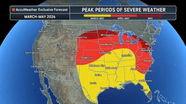
High-Risk Zones: Where and When
The AccuWeather forecast identifies specific regions that should remain on high alert. For March and April, the primary severe weather episodes are expected to focus on the eastern Plains, stretching into the mid-Mississippi Valley and the western Ohio Valley.
States currently in the “crosshairs” for storms containing large hail and damaging winds include:
- The Southern Plains: Texas, Oklahoma, and Kansas.
- The Deep South: Arkansas, Louisiana, Mississippi, and Alabama.
- The Midwest: Missouri, Nebraska, Iowa, and Illinois.
In the early part of the season, cooler and more stable air in the northern latitudes is expected to act as a shield, limiting severe activity in the northern Plains and Great Lakes. However, as the calendar turns to late April and May, that shield will retreat. AccuWeather experts predict an uptick in traditional “Tornado Alley” activity—centered on the western Plains—later in May as the atmosphere becomes more volatile in those regions.
The Growing Threat of Extreme Rainfall
One of the most sobering aspects of the 2026 outlook is the emphasis on flooding. While total annual rainfall across the contiguous U.S. has declined by 2.7% since 1995, the intensity of individual rain events is skyrocketing.
According to a recent AccuWeather climate study, the frequency of extreme rainfall events—defined as more than 4 inches of rain falling within a 24-hour period—has surged by 70%. This trend is expected to manifest clearly in 2026. Because the projected storm patterns favor slower-moving or repeating thunderstorm complexes, the risk of flash flooding is significantly higher than in 2025.
“Flash floods and damaging wind gusts can be just as destructive as tornadoes and often impact a much larger area,” Duffus noted. “It only takes one storm striking a densely populated or vulnerable community to make this a devastating season.”
Preparation is Paramount
With the season poised to ramp up, AccuWeather is urging families and businesses to prioritize safety over statistics. Meteorologists recommend several immediate steps:
- Review Insurance: Ensure that policies cover wind and flood damage, as these are often separate riders.
- Audit Supplies: Restock emergency kits with fresh water, non-perishable food, batteries, and first-aid supplies.
- Clear Shelters: Ensure that basements, storm cellars, or interior “safe rooms” are free of clutter and easily accessible.
- Stay Informed: Utilize tools like the AccuWeather app, which provides lightning alerts and severe weather warnings that often arrive faster than government sources.
The 2025 season may have been more prolific in terms of tornado counts, but 2026 presents a more diverse and deceptive set of challenges. By focusing on the broader spectrum of severe weather—including the “silent killers” of flooding and straight-line winds—residents can better prepare for a season that promises to be anything but quiet.
As the atmosphere transitions and the first major spring systems begin to form, the experts at AccuWeather remain vigilant. The forecast serves as a reminder that in meteorology, “fewer” does not mean “less dangerous.” It simply means the danger is changing its shape.
Source: AccuWeather
The post by SouthFloridaReporter.com appears on South Florida Reporter.
VIP Journal Media


