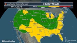
As hundreds of millions of people prepare to celebrate America250, those planning cookouts, beach trips, lake days, other trips and fireworks celebrations should prepare for a taste of midsummer heat. “It will turn very hot and humid in the East by...
As hundreds of millions of people prepare to celebrate America250, those planning cookouts, beach trips, lake days, other trips and fireworks celebrations should prepare for a taste of midsummer heat.
“It will turn very hot and humid in the East by early next week (June 29-30),” AccuWeather Senior Meteorologist Chad Merill said. “Multiple days with highs well into the 90s are likely along the Interstate 95 Corridor in the mid-Atlantic.”
Temperatures are expected to climb into the 90s across much of the central and eastern United States, with some communities experiencing multiple days of hot, humid conditions before the holiday weekend arrives. In many areas, AccuWeather RealFeel® Temperatures could top 100 degrees during the afternoon.
AccuWeather Forecast Day by Day for the Fourth of July Week at a Glance
Monday (6/29)
- Heat begins expanding from the Plains into the Midwest and Ohio Valley
- Humidity increases, making conditions feel significantly hotter than the air temperature
Tuesday (6/30)
- Hot weather spreaders farther east into the Great Lakes, Tennessee Valley and portions of the mid-Atlantic
- Thunderstorms develop along the northern edge of the heat dome from the Dakotas into the Upper Midwest
Wednesday (7/1)
- The core of the hottest weather settles over the Ohio Valley, middle Mississippi Valley and Tennessee Valley
- Some storms north of the heat could become severe, bringing damaging winds and flooding downpours
Thursday (7/2)
- Heat intensifies across much of the East as holiday travel ramps up
- The timing of thunderstorms may determine just how it gets in parts of the Northeast
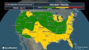
Friday (7/3)
- Most locations beneath the heat dome remain sunny and dry
- A strong front could trigger thunderstorms from the Great Lakes into the Northeast, potentially disrupting holiday travel
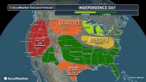 Independence Day
- Hot, humid weather continues while celebrating America250
- Many places will enjoy favorable conditions for parades, cookouts and fireworks, though scattered thunderstorms may interrupt festivities across parts of the Great Lakes and Northeast
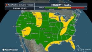 Sunday (7/5)
- Warm weather lingers across much of the Midwest and East as many return home after the holiday weekend
- Scattered thunderstorms remain possible in portions of the Northeast
What’s Driving the Forecast?
The prolonged stretch of summer weather is being fueled by a sprawling heat dome, a large area of high pressure that traps warm air near the ground and allows temperatures to build over several days. Areas beneath the center of the heat dome are expected to remain mostly sunny and dry, while disturbances riding along its northern edge can spark rounds of thunderstorms.
“With heat and humidity nearby, any clusters of thunderstorms that develop can produce damaging winds, resulting in downed trees, power outages, and other damage. Intense thunderstorm clusters can even form into a derecho, a long-lived and significant windstorm. The risk of thunderstorm clusters with damaging winds may be highest next Tuesday or Wednesday,” said AccuWeather Chief Meteorologist Jon Porter.
The post by AccuWeather.com appears on South Florida Reporter.
VIP Journal Media