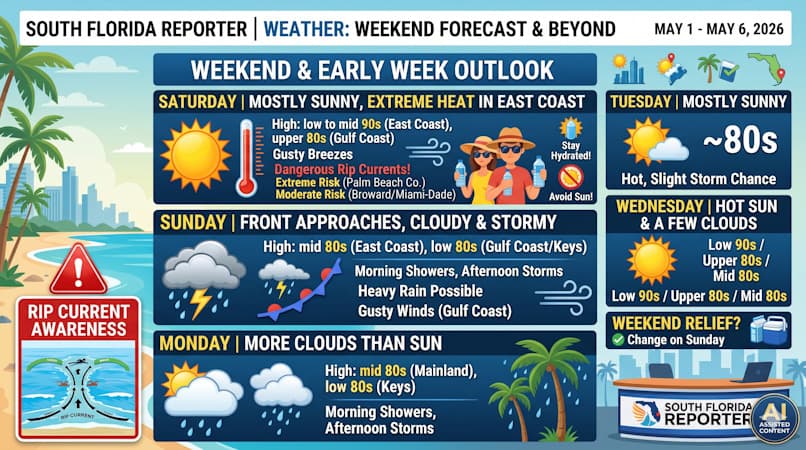
Saturday brings sweltering heat and dangerous rip currents before Sunday morning showers and afternoon storms provide cooling relief.
Saturday features mostly sunny skies and gusty breezes. Expect extreme heat in the East Coast, so be sure to stay hydrated and out of the sun. Look for some evening showers and storms on the mainland as a front approaches. A high risk of dangerous rip currents remains along the Palm Beach County coast, and there’s a moderate rip current risk at the Broward and Miami-Dade beaches. Saturday’s highs will be mostly in the low 90s in the East Coast, with some locations reaching the mid-90s. Highs along the Gulf Coast will be in the upper 80s, while the Keys will top out in the mid 80s.
Sunday will bring plenty of clouds, morning showers, and afternoon storms. Heavy rain is possible in spots, and the Gulf Coast will also see gusty winds. Sunday’s highs will be in the mid-80s on the East Coast and in the low-80s along the Gulf Coast and in the Keys.
Monday will feature more clouds than sun, morning showers, and afternoon storms. Monday’s highs will be in the mid-80s on the mainland and mostly in the low-80s in the Keys.
Tuesday will see mostly sunny skies around South Florida, but we can’t rule out a stray storm in the east coast metro area. Tuesday’s highs will be in the mid 80s.
Wednesday’s forecast calls for hot sun and a few clouds throughout the area. Highs on Wednesday will be mostly in the low 90s in the East Coast, mostly in the upper 80s along the Gulf Coast and in the Keys.
The post by Donna Thomas, Meteorologist appears on South Florida Reporter.
Теги
VIP Journal Media


