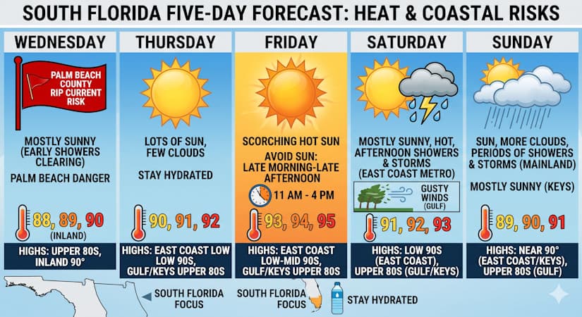
South Florida will experience rising temperatures and coastal rip current risks before scattered afternoon thunderstorms arrive this weekend.
Wednesday features a few early showers on the mainland and mostly sunny skies around South Florida. Expect an elevated risk of dangerous rip currents to linger along the Palm Beach County coast. Wednesday’s highs will be mostly in the upper 80s, with a few suburban and inland locations reaching the 90-degree mark.
Thursday will bring lots of sun and just a few clouds to the mainland, while the Keys will see a nice mix of sun and clouds. Thursday’s highs will be in the low 90s in the East Coast and in the upper 80s along the Gulf Coast and in the Keys — so be sure to stay hydrated.
Friday will feature plenty of hot sun and a few clouds around South Florida. Be sure to stay hydrated and out of the sun from late morning to late afternoon. Friday’s highs will be in the low to mid 90s on the East Coast and in the upper 80s along the Gulf Coast and in the Keys.
Saturday will be mostly sunny and hot, with a few mid- to late-afternoon showers and storms in the East Coast metro area. The Gulf coast will see sun, clouds, and a few showers and storms, with gusty winds. Look for mostly sunny skies in the Keys. Saturday’s highs will be in the low 90s in the East Coast and in the upper 80s along the Gulf Coast and in the Keys.
Sunday’s forecast calls for some hot sun, more clouds, and periods of showers and storms on the mainland, while the Keys will be mostly sunny and hot. Highs on Sunday will be near 90 degrees in the East Coast and the Keys, and in the upper 80s along the Gulf Coast.
The post by Donna Thomas, Meteorologist appears on South Florida Reporter.
Теги
VIP Journal Media


