South Florida faces a hot week with wildfire smoke and afternoon storms, while quiet tropics offer no new development.
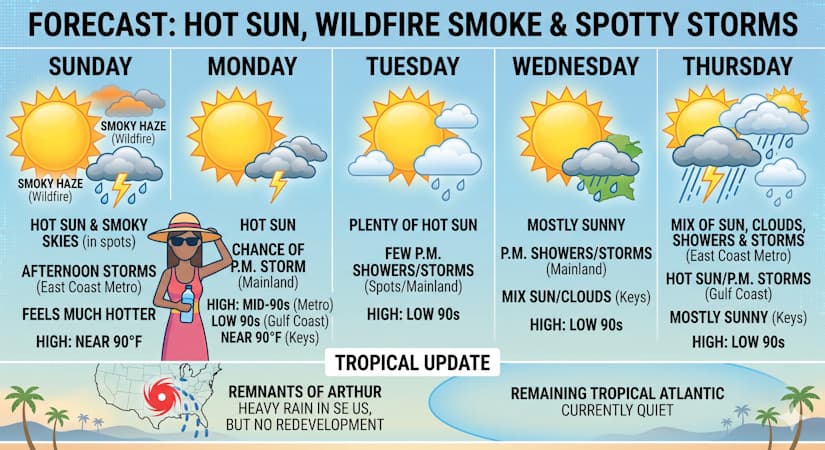
Sunday features hot sun, smoky skies in spots from wildfires, and periods of afternoon storms in the East Coast metro area. The Gulf Coast and the Keys will be sunny and hot. Sunday’s highs will be near 90 degrees — but it will feel much hotter, so stay hydrated and out of the sun.
Monday will bring hot sun and the chance of an afternoon storm to the mainland. The Keys will see mostly sunny skies. Monday’s highs will be mostly in the mid-90s in the East Coast metro area, in the low 90s along the Gulf Coast, and near 90 degrees in the Keys.
Tuesday will feature plenty of hot sun and a few clouds around South Florida. The mainland will also see a few afternoon showers or storms in spots. Tuesday’s highs will be mostly in the low 90s.
Wednesday will be a mostly sunny day with some afternoon showers and storms on the mainland. Look for a mix of sun and clouds in the Keys. Wednesday’s highs will be in the low 90s.
Thursday’s forecast calls for a mix of sun, clouds, showers, and storms in the East Coast metro area, while the Gulf Coast will see hot sun with some afternoon storms. The Keys will be mostly sunny. Highs on Thursday will be in the low 90s again.
While the remnants of Arthur continue to drop heavy rain in the southeastern US, redevelopment is not expected. And the rest of the tropical Atlantic is quiet right now.
The post by Donna Thomas, Meteorologist appears on South Florida Reporter.
VIP Journal Media