Heavy snow, ice, and severe thunderstorms will disrupt millions of travelers through the busy Easter weekend across the country.
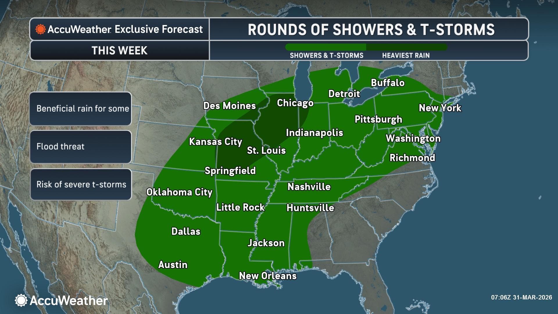
A volatile and highly disruptive spring weather pattern is currently unfolding across the United States, as a powerful clash of air masses threatens to upend travel plans for millions of Americans during the peak Spring Break and Easter holiday period. According to AccuWeather expert meteorologists, a dangerous combination of severe thunderstorms, flooding downpours, and a significant midweek winter storm will impact a vast corridor stretching from the Plains and Mississippi Valley to the Great Lakes and central Appalachians.
The timing of this multi-faceted weather event could not be worse for travelers. With Easter Sunday approaching and many schools on spring break, highways and airports are expected to be at their busiest. AccuWeather forecasts that the combination of severe weather in the South and East and wintry conditions in the North could lead to more than 3,000 flight cancellations nationwide through Saturday night.
A Dangerous Clash of Seasons
The primary driver behind this week’s atmospheric volatility is a rapid warmup across parts of the Midwest and Northeast, which is setting the stage for dramatic temperature swings. As warm, moist air surges northward from the Gulf of Mexico, it is being met by a secondary, surging push of chillier air from Canada. This atmospheric “tug-of-war” provides the necessary fuel for multiple rounds of powerful thunderstorms capable of producing large hail, damaging winds, and isolated tornadoes.
“Severe weather season is ramping up in full force this week, and it’s happening during one of the busiest travel periods of spring,” said Carl Erickson, AccuWeather Director of Forecasting Operations. “A volatile clash between building warmth and a surging push of chillier air, combined with moisture from the Gulf, will fuel multiple rounds of powerful and disruptive thunderstorms.”
Detailed Severe Weather Timeline
The threat of severe weather is not a one-day event but a multi-day progression that will shift across different regions of the country as the week continues.
- Tuesday Night Impact: The severe weather zone is currently expanding from central Oklahoma and eastern Kansas through western Pennsylvania and New York. Meteorologists are particularly concerned with the corridor from southern Michigan to northern Indiana and Ohio, where the greatest concentration of severe storms is expected. These areas could see damaging wind gusts of 60-70 mph, with an AccuWeather Local StormMax™ of 85 mph.
- Wednesday Outlook: By Wednesday, the focus of the most intense activity will shift farther south. Parts of Texas, Oklahoma, Kansas, and Missouri are in the crosshairs for severe thunderstorms. Simultaneously, heavy thunderstorms are expected to drench parts of the Mid-Atlantic, potentially slowing commutes in major metropolitan areas.
- Thursday Progression: The risk persists across the Mississippi Valley and the Plains. While the storms may be more localized, they remain dangerous, with wind gusts of 50-60 mph likely to cause minor property damage and power outages.
- Friday and Saturday Escalation: As we head into the holiday weekend, the risk shifts from central Texas toward southern Nebraska and Iowa on Friday. By Saturday, a broad zone of severe weather will extend from the Gulf Coast all the way to the Great Lakes, including parts of Michigan, Pennsylvania, and upstate New York.
“Powerful wind gusts, hail, and flooding downpours are the most widespread hazards expected this week,” Erickson warned. “Several tornadoes are possible. The most intense weather may strike after dark, so make sure you have multiple ways to receive severe weather warnings that can wake you up.”
Flooding and the Drought Context
Beyond the immediate threat of wind and tornadoes, flooding downpours represent a significant hazard to motorists. AccuWeather forecasts a general 1-4 inches of rain this week across a wide swath of the country. However, in areas where storms stall or “train” over the same ground, rainfall totals could reach up to 6 inches, according to the AccuWeather StormMax™.
While the rain creates travel hazards, it is not entirely unwelcome. Approximately 29% of the continental United States is currently experiencing severe, extreme, or exceptional drought conditions. This moisture will be beneficial for agricultural interests in the Plains and Southeast, though the rate at which it falls may lead to flash flooding before the parched soil can fully absorb it.
Midweek Winter Storm: A “Spring” Reality Check
While the southern half of the storm system produces thunderstorms, the northern edge will feature a late-season winter storm. From Wednesday night through Friday morning, a swath of snow and ice is forecast to track from the Dakotas through the Great Lakes and into southern Canada and Maine.
“Do not let the calendar fool you. It may be springtime, but high-impact snow and ice storms can still cause major disruptions in April,” said Erickson.
Snow and Ice Accumulations:
- Snowfall: A broad area of 3-6 inches of snow is expected along the northern periphery of the storm. However, heavier bands are likely to produce 6-12 inches, with an AccuWeather Local StormMax™ of 14 inches.
- Icing: South of the heavy snow, a dangerous zone of freezing rain and sleet is expected. This icing threat covers parts of Iowa, Minnesota, Wisconsin, and the Upper Peninsula of Michigan. Icy roads are often more treacherous than snowy ones, and even a thin glaze can lead to multi-vehicle accidents and downed power lines.
Major Travel Disruptions Expected
The intersection of severe storms in the South and a winter storm in the North creates a “pincer maneuver” on the U.S. transportation network. Major airline hubs, including Chicago O’Hare, Detroit Metropolitan, and Minneapolis-Saint Paul, are all in the path of these weather systems.
AccuWeather experts predict that the cumulative effect of these storms will result in more than 3,000 flight cancellations by late Sunday night. Travelers are urged to check their flight status frequently and consider traveling earlier or later if their route takes them through the impacted regions.
On the ground, major arteries such as I-80, I-90, and I-35 will likely see significant slowdowns. Flooding in the Ohio and Mississippi Valleys and snow/ice in the Great Lakes region will make long-distance driving hazardous.
Summary of AccuWeather Local StormMax™ Projections
| Hazard | Potential Intensity | Region |
| Wind Gusts | Up to 85 mph | Midwest and Ohio Valley |
| Snowfall | Up to 14 inches | Upper Midwest and Great Lakes |
| Rainfall | Up to 6 inches | Gulf Coast to Appalachians |
| Ice | Significant Glazing | MN, WI, MI (U.P.) |
As the Easter weekend approaches, AccuWeather will continue to provide real-time updates. Those with outdoor plans or travel itineraries should remain vigilant and have a plan in place for seeking shelter should severe weather approach.
Sources Used and Links
- AccuWeather Newsroom: https://www.accuweather.com/en/weather-news
- AccuWeather Severe Weather Center: https://www.accuweather.com/en/us/severe-weather
- AccuWeather Winter Weather Center: https://www.accuweather.com/en/us/winter-weather
The post by SouthFloridaReporter.com appears on South Florida Reporter.
VIP Journal Media


