AccuWeather experts warn of a rapidly intensifying storm system bringing historic snowfall, tornadoes, and widespread power outages across North America.
AccuWeather Issues Urgent Warning for Sprawling March Megastorm
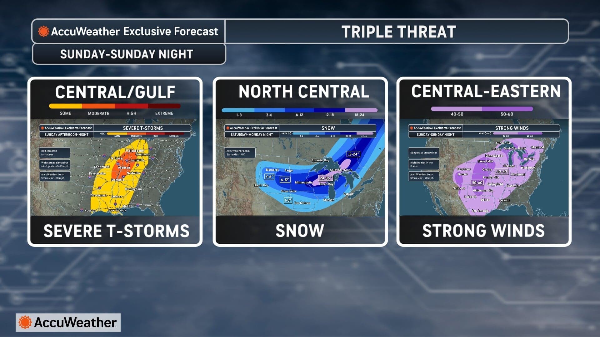
As mid-March 2026 arrives, a weather event of historic proportions is taking shape over the heart of North America. AccuWeather expert meteorologists are tracking a rapidly intensifying and expansive “megastorm” that threatens to disrupt the lives of nearly 200 million people across the United States and Canada. This system is a “triple threat,” consisting of a crippling blizzard in the north, a violent severe weather outbreak in the south, and a massive field of damaging winds stretching from the Southwest to the East Coast.
“This is shaping up to be one of the most expansive and impactful storms that the United States has experienced so far this year,” AccuWeather Senior Meteorologist John Feerick said. The scale of the system has forecasters deeply concerned as it interacts with an advancing surge of Arctic air, providing the thermal contrast necessary for explosive intensification.
Blizzard Conditions and Historic Snowfall in the North
For the Upper Midwest and central Canada, AccuWeather reports the primary threat is a classic, high-impact winter storm. As the low-pressure center strengthens over the Plains from Saturday through Monday, it will pull moisture from the Gulf of Mexico and crash it into sub-freezing air diving south from the Arctic.
According to AccuWeather, a massive “snow zone” will stretch from the Dakotas through Minnesota, northern Iowa, and across the Great Lakes. The hardest-hit regions, including central and northern Wisconsin and the Upper Peninsula of Michigan, could see snowfall totals of 1 to 3 feet. This heavy snow, combined with wind gusts of 40 to 60 mph, is expected to create true blizzard conditions.
“The combination of heavy snow and strong winds could make travel extremely dangerous in parts of Wisconsin and Michigan where visibility may drop to near zero during the height of the storm,” Feerick warned in an AccuWeather release. Beyond the snow, AccuWeather forecasters identify a dangerous “icing corridor” of sleet and freezing rain from Iowa into southern Wisconsin and northern Illinois, which could coat power lines and trees in a destructive layer of ice.
Severe Thunderstorms and Tornadoes Threaten the South and East
While the north freezes, AccuWeather notes that the storm’s southern and eastern flanks will be characterized by extreme instability. A line of severe thunderstorms is expected to form Sunday in the Mississippi Valley and expand toward the East Coast by Monday.
AccuWeather warns that the atmospheric setup is conducive to widespread damaging wind gusts, large hail, and the potential for several tornadoes. The risk zone is expansive, starting in Texas and Ohio on Sunday before shifting toward major population centers including Washington, D.C., Philadelphia, Pittsburgh, Charlotte, and Baltimore by Monday. “Storms will be capable of producing widespread damaging wind gusts, hail, and a few tornadoes,” Feerick stated via AccuWeather.
A National Wind Event: Power Outages and Travel Chaos
A universal aspect of this megastorm is its massive wind field. AccuWeather experts say that even in areas without snow or lightning, the pressure gradient created by the intensifying storm will produce dangerous winds. Starting in the Rockies and Southwest this weekend, 40 to 60 mph gusts will rake across dozens of states.
“Far from the snow zone, the storm’s wind field alone could cause major issues,” Feerick warned according to AccuWeather. These winds are capable of causing widespread power outages and hazardous travel. AccuWeather expert meteorologists project that more than 4,400 flight cancellations are expected across the country between Sunday and Tuesday. Major interstates, including I-29, I-35, I-41, I-75, I-80, I-90, I-94, and I-96, are likely to see hazardous travel or closures.
Summary of Impacts According to AccuWeather
| Forecast Impact | Primary Locations | Expected Timing |
| Blizzard/1–3ft Snow | WI, MI, MN, Canada | Sat – Mon |
| Severe Storms/Tornadoes | TX to OH, East Coast | Sun – Mon |
| High Winds (40-60 mph) | Southwest to New England | Sat – Mon |
| Icing Corridor | IA, IL, Southern WI | Sunday |
| Aviation Disruptions | 4,400+ Cancellations | Sun – Tue |
As the storm exits the East Coast late Monday into Tuesday, AccuWeather predicts a dramatic drop in temperatures that could lead to a “flash freeze,” turning wet roads into sheets of ice. Authorities and AccuWeather experts urge the public to complete storm preparations by Friday evening and stay tuned to the AccuWeather Newsroom for the latest updates.
Source: AccuWeather Newsroom: https://www.accuweather.com/en/weather-news
The post by SouthFloridaReporter.com appears on South Florida Reporter.
VIP Journal Media


