Expect gusty winds and scattered showers with dangerous rip currents as warm temperatures remain steady across South Florida.
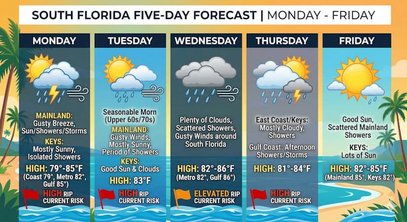
Monday features a gusty breeze, with a mix of sun, showers, and storms on the mainland. The Keys will see mostly sunny skies and a few showers in spots. A high risk of dangerous rip currents continues at the Atlantic beaches. Monday’s highs will be in the upper 70s right along the Atlantic coast, in the low 80s elsewhere along the East Coast, in the Keys, and in the mid 80s along the Gulf Coast.
Tuesday will bring seasonable morning lows in the upper 60s to low 70s. Then look for gusty breezes, mostly sunny skies, and periods of showers on the mainland. The Keys will see good sun and some clouds at times. Expect a high risk of dangerous rip currents at the Atlantic beaches. Tuesday’s highs will be mostly in the low 80s.
Wednesday will feature plenty of clouds and a few showers, with gusty winds around South Florida. Expect an elevated risk of dangerous rip currents at the Atlantic beaches. Wednesday’s highs will be in the low 80s in the East Coast metro area and the Keys and in the mid-80s along the Gulf Coast.
Thursday will be mostly sunny with a few afternoon showers and maybe a storm along the Gulf coast, but the east coast metro area and the Keys will see more clouds than sun along with some showers. Thursday’s highs will be in the low 80s in the East Coast and the Keys and in the mid-80s along the Gulf Coast.
Friday’s forecast calls for good sun and a few clouds and showers on the mainland, while the Keys will see lots of sun. Highs on Friday will be mostly in the mid-80s on the mainland and in the low-80s in the Keys.
The post by Donna Thomas, Meteorologist appears on South Florida Reporter.
Теги
VIP Journal Media


