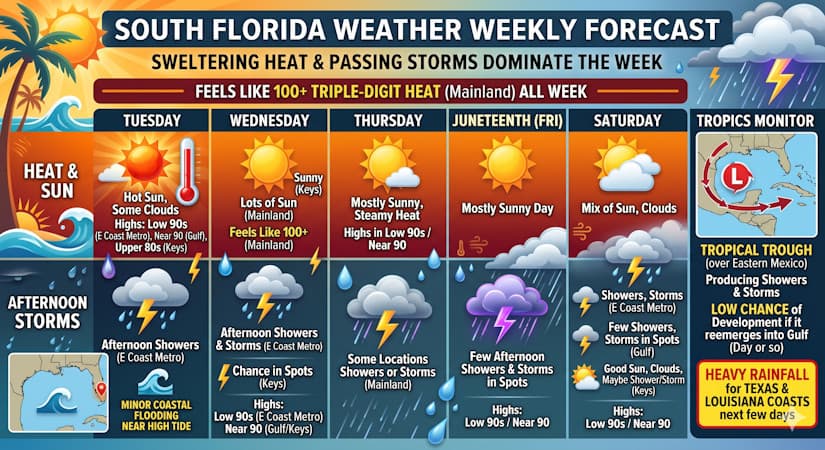
Expect triple digit heat indexes and daily afternoon storms across South Florida while the Gulf monitors tropical development.
Tuesday features hot sun, some clouds, and afternoon showers and storms in the East Coast metro area. The Gulf Coast will be mostly sunny and hot, while the Keys will see lots of sun. Minor coastal flooding is likely near high tide along the Gulf Coast. Tuesday’s highs will be in the low 90s in the East Coast metro area, near 90 degrees along the Gulf Coast, and in the muggy upper 80s in the Keys. But it will feel like the triple digits on the mainland — so stay hydrated and out of the sun.
Wednesday will bring lots of sun to the mainland, but the East Coast metro area will also see some afternoon showers and storms. The Keys will see sunny skies, with a chance of showers or storms in spots. Wednesday’s highs will be in the low 90s in the East Coast metro area and near 90 degrees along the Gulf Coast and in the Keys.
Thursday will feature mostly sunny skies and steamy heat around South Florida. Some locations on the mainland could also see showers or storms. Thursday’s highs will be in the low 90s in the East Coast metro area and near 90 degrees along the Gulf Coast and in the Keys.
Juneteenth will be another mostly sunny day with a few afternoon showers and storms in spots. Friday’s highs will be in the low 90s in the East Coast metro area and near 90 degrees along the Gulf Coast and in the Keys.
Saturday’s forecast calls for a mix of sun, clouds, showers, and storms in the East Coast metro area. The Gulf Coast will be mostly sunny with a few showers and storms in spots, while the Keys will see good sun and a few clouds with maybe a shower or storm. Highs on Saturday will be in the low 90s in the East Coast metro area and near 90 degrees along the Gulf Coast and in the Keys.
In the tropics, a trough over eastern Mexico is producing showers and storms. A low chance of development is possible if it reemerges into the Gulf in a day or so. Whether or not this feature reaches depression status, it will bring heavy rain to the Texas and Louisiana coasts during the next few days.
The post by Donna Thomas, Meteorologist appears on South Florida Reporter.
VIP Journal Media